Latitude
Seeker
Portraits of America’s
40th Parallel
I actually would like people to stand in their space and consider where they are and really understand their localness. Just going, 'okay, this is where I am.
Interview by Heidi Legg
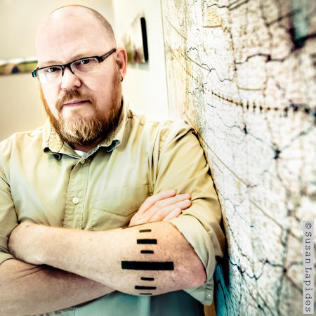
Bruce Myren set out to photograph the 40th Parallel of America. The photographs are stunning. He's driven taxis, moved computers, been a Kelly Girl, worked as a janitor at a methadone clinic and in color photo labs - all in the name of supporting his work. Today he photographs and teaches photography at Northeastern and Lesley College of Art and Design.
What's on your desk?
It's all related; the new project that I'm trying to get off the ground, The Washington Elm, a continuing project that I haven't finished called Fort Juniper, and the 40th Parallel work that I’m promoting. They all involve a sense of place.
The middle project, which I've been working on since late 2008/early 2009, is enormous and called Fort Juniper. I'm thinking that it needs another five years. It's one of those things where I just go out and photograph in these woods where I grew up. It's an exploration of this forest in Western Massachusetts along The Mill River that's conservation land. It runs from where I grew up to Fort Juniper, which is the small one-person house built by poet Robert Francis. He built the house in 1940.
It’s first an exploration of the house and his experience on that landscape, and then of my experience growing up around this landscape. How do those two things interact through time? I grew up in the Pioneer Valley near Amherst, MA. My formative years were there, and I spent hours in that stretch of woods along the Mill River. It’s where I started to understand my relationship to land and landscape.
How do you understand that relationship today?
Wow, that's a really hard question… I'm really concerned with place and how I find myself in the world and by that extension, how other people find themselves in the world. Where are we? And how do we navigate the local space around us?
How does technology play in that role?
Naturally, humans navigate by relative spatial analysis. They look at their landscape and they find landmarks. It's all very relative and it's all very personal. We've always had maps, but as technology comes into play and we use GPS to guide us, it's actually an absolute system of location. GPS is set on global positions that don't translate into human experience at all.
What's interesting to me is you see people using these to go to the grocery store in their neighborhood, to go to their parent's house a hundred miles away or across town, and they're losing how to navigate themselves.
The question is do we rely on this technology too much? Similar to if I was to ask you to remember your friend's phone numbers. I remember a couple, but mostly they're in your phone. You don't remember them. Our memory is different than it used to be.
Are you worried we're not going to get lost anymore?
In a way, yeah. I'm so fascinated with this because at one time when I was about six or seven, I got very, very lost. It was my very first weekend in Amherst when we moved from the South Shore, and I met another boy who took me on a walk and he abandoned me. The panic of not knowing where I was in a new environment made me really pay attention to where I was after that.
Now when I try to get lost, it's really hard for me because I pay really good attention. I don't always know the direction I'm going, but I know how to get back.
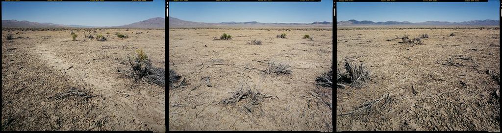
When and why did you photograph the 40th Parallel of the US?
The 40th Parallel series began in concept in 1992. My father was a draftsman and an engineer, and was fascinated with surveying work he did while in college. It dovetails into my interest in place and location. In the late '80s, I’d been trying to use latitude and longitude - that idea of exacting location – to inform my photography, but nothing worked. It just didn't work. So I moved to Boulder, Colorado in 1991, determined to go to graduate school, after I graduated from the Massachusetts College of Art with my BFA in Photography. But while I was there, I saw Baseline Road, and my friend Eric told me that Baseline Road is the 40th Parallel. It's called Baseline Road because the 40th Parallel was a baseline for surveying the Kansas/Nebraska Territory in the 1850s.
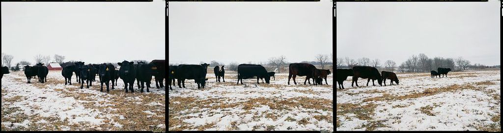
When I realized that Baseline Road went east as far as I could see, I started researching it. I could see that I could make this an important line, and in that process I also knew I wanted GPS. I wanted to be able to have the exact location of where the longitude crossed the parallel, and you can do that on maps but it's very, very difficult. At that time I understood that GPS was coming along and already available to surveyors, and of course the military. So I waited until I could afford one to make a picture. I made my first picture in the series in 1998.
Was there any political motivation for you?
Not overtly political but the idea of place, the idea of location, how we settled the west, the western expansion, those ideas of displacement and exploitation of landscape, and how we came to be as a country motivated me.
When did you know that you were onto something?
Honestly, the very moment I thought 'this is a project'. It was strange. I was like, 'this is bigger than me,' and I knew that I had to do it. I was very careful not to tell anybody except very close friends until I had GPS and made my first picture about the project. Only now is it getting success. With a project like this, it has to be finished to really take hold and that took a long time.
Did it change in your mind from start to finish?
Yes, the approach to the photographs changed a few times. In the very first incarnation of it, I was going to do every ten degrees and then every five degrees of longitude, and I then realized that that wouldn't be enough. I wanted a contemporary response to 19th Century landscape surveys, similar to the Clarence King survey (first director of the United States Geological Survey) of the 40th Parallel. There were four large surveys done in the 1860s into the 1870s of the West. The government wanted to see what kind of minerals could be mined, what we could extract. Where could the railroads go?
On the first survey by Clarence King in 1867, he brought artists and other scientists and Timothy O' Sullivan who was a Civil War photographer. (This was the first federal expedition of the West after the Civil War). He starts out from California and works his way towards Wyoming and maybe even a little bit of South Dakota, but it's a swath of the 40th Parallel. It's not along the line like mine. It's actually kind of between 40th and 41st in this very broad kind of understanding.
How many photos are in that project?
There are 52 panoramas in total: 50 on the land at the intersection of the 40th Parallel with every whole degree of longitude and two at landfall.
Who do you see owning this series?
I'm hoping that we will be able to place a few of the complete portfolios into institutions. There are some public, as well as private collections have shown interest in owning a set. The Library of Congress and the Smithsonian are collections I am most interested in having copies.
Ideally I would like the project it to be available to the public in some way. For this reason, I would like to publish the project as a book. I'm working on a few proposals to publishers, but I am also still looking around. The most difficult part is producing a book that's affordable but still meets all of my requirements for quality.
Tell us about the Washington Elm project.
I just wrote a Cambridge Arts Council grant for it yesterday, so I'm hoping that comes through. The project will go forward whether or not that happens. The Washington Elm is really a photographic exploration of that famous tree on Cambridge Common, what it meant in the past and what it means now, and what we mean with the idea of a 'historical marker.'
How did you come to focus on this?
In 2006, I had stopped working on The 40th Parallel and in some ways taken a bit of a hiatus from making art photography. I decided I would walk out my door and start making pictures without any pre-conceived idea. It was a Sunday afternoon in January. I walked on the Cambridge Common and for the very first time, I noticed the John Bridge Statue. It made me think about what a monument was. I'd walked on that space so many times and actually not really paid attention. In standing there watching other people walk by without noticing it or stopping, I started thinking about the history of Cambridge and Boston and how we walk on history every single day. We literally walk on top of it and we don’t pay attention. Of course, we can't pay attention to everything in our everyday or else we wouldn't get anything done, but in some ways that's my big fear.
I started making these pictures about monuments and researching what they meant and the history behind them, and I did a very small series - only eight or ten pictures. In that process, I discovered the Washington Elm or specifically a scion of the Washington Elm, planted in about 1923 on Cambridge Common. It was actually taken from another scion that was taken from the original tree in the 1880s.
In 1923 when the original Washington Elm died, they then took a scion from one that was given to the state of Washington at one time, and brought it back and planted it on the Common around the Centennial of the country - all things being 'Washington'. The DAR was doing this kind of thing in earnest towards the 150th anniversary of Washington's birth in 1932.
What public opinion would you like to change?
I always come back to the idea that I want people to understand that it doesn't matter where you are, there's beauty everywhere. There's a way to see something as new and beautiful. I can get into a lot of trouble for that word. There's a great book called Beauty in Photography: Essays in Defense of Traditional Values by Robert Adams in the '70s. It's a really important book.
Also, I actually would like people to stand in their space and consider where they are and really understand their localness. Just going, 'okay, this is where I am.'
Why do you want that?
I think it empowers people. I think it empowers you to understand your life better and the world around you. If you care about your local thing, that extends out. It's a Buddhist thing. If you try to end your own suffering, then you've helped other people end suffering. Caring about your own local environment just translates everywhere else, because it's contagious.
Art is not easy. What other jobs have you had?
One was a bag boy at a grocery store when I was sixteen, and the sports photographer in high school at my local weekly newspaper. I was a custom color photo lab technician. I worked in a color lab before college and during college. While I was in college I also drove a taxi for a while. I was a janitor at a methadone clinic. I was a Kelly Girl; I worked for Kelly Temporary Services in Colorado, and I worked in a warehouse moving computers. I did anything that I could do to support my work.
And Today?
Now I teach and I do a little bit of freelancing. Right now I'm teaching photography at the Lesley University College of Art & Design, and I teach at Northeastern University.
Where are you showing next?
My next show will be The Washington Elm project in the fall of 2014 at the Cambridge Historical Society, currently being renovated on Brattle Street.
Who are your favorite photographers?
My former professor at Mass Art, Barbara Bosworth; she's probably the most important person in my life. As far as my approach to how I think about landscape and how I think about where I am and that whole idea of the backyard place being important - that really comes from her.
The other person that I think about a lot is John Hanson Mitchell. He's the editor of Sanctuary, which is the Audubon Society magazine. He lives in Littleton but he's written a number of completely local books. His first book is called Ceremonial Time and it's a ten thousand year history of a single square mile of land in Littleton.
What your news source?
Twitter. A lot of Twitter.
Who do you follow?
MSNBC. I've actually been reading a lot of Al Jazeera America and the BBC once in a while. They offer a different perspective than the whole US machine.
Favorite place to have a drink with friends?
One is the Cambridge Common because that's the cheapest pint of IPA in the city, and it's great. And Shays Pub right in Harvard Square, because I’ve been going there since college.
@bmyren_studio